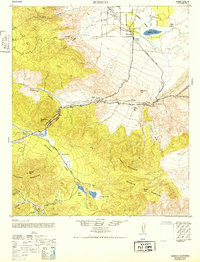
1942 Map of Borrego
USGS Topo · Published 1952About this map
Borego and its surrounding desert valley serve as the focal point for this mid-century topographic study, capturing the early layout of the Desert Lodge and the sparse ranching outposts of San Diego County. The landscape is defined by its seasonal water features and ancient travel corridors, including the Old Overland Stage Route which winds through Earthquake Valley toward Blair Valley. This route provides a clear look at the historical transit patterns through the Vallecito Mountains and Pinyon Mountains before the expansion of modern highway networks.
Find a feature on this map
34 named features on this map. Tap any name to fly to it.
Don’t see what you’re looking for? This feature index may not catch every label — zoom into the map to look around manually.
Map Details
Editions of this 1942 Borrego Map
2 editions found

Other maps of this area

1903 · Cuyamaca
USGS Topo · 1:125,000

1903 · Ramona
USGS Topo · 1:125,000

1904 · Indio
USGS Topo · 1:125,000

1904 · Southern California Sheet No. 2
USGS Topo · 1:250,000

1931 · Vallecito
USGS Topo · 1:125,000

1931 · Carrizo
USGS Topo · 1:125,000

1939 · Warner Springs
USGS Topo · 1:62,500

1939 · Santa Ysabel
USGS Topo · 1:62,500

1939 · Borrego
USGS Topo · 1:62,500

1941 · Clark Lake
USGS Topo · 1:62,500