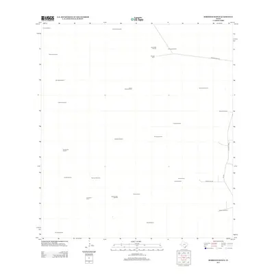
2012 Map of Borregos Ranch
USGS Topo · Published 2012About this map
Borregos Ranch anchor this landscape in Starr County, part of a sparsely settled ranching region defined by an extensive network of groundwater extraction points. The map reveals a highly specialized land use pattern where named windmills, such as Viente dos Windmill and San Juan Windmills, serve as the primary landmarks across the brushland. These features indicate the vital importance of water management in sustaining livestock operations in this part of South Texas. Transport in the area is largely confined to utility and ranch roads, including Borregos Ranch Rd and FM-1017, which connect the disparate homesteads. Other localized sites like Granjenitos Ranch and Juanitas Ranch highlight the enduring presence of family-operated landholdings and the quiet scale of rural development during this era.
Find a feature on this map
29 named features on this map. Tap any name to fly to it.
Don’t see what you’re looking for? This feature index may not catch every label — zoom into the map to look around manually.
Map Details
Editions of this 2012 Borregos Ranch Map
This is the sole edition of this map. No revisions or reprints were ever made.
Other maps of this area

1938 · El Sauz
USGS Topo · 1:62,500

1938 · Agua Nueva
USGS Topo · 1:62,500

1938 · Sal Colorada
USGS Topo · 1:62,500

1938 · Cuevitas
USGS Topo · 1:62,500

1949 · Mc Allen
USGS Topo · 1:250,000

1954 · McAllen
USGS Topo · 1:250,000

1957 · Mc Allen
USGS Topo · 1:250,000

1962 · McAllen
USGS Topo · 1:250,000

1972 · Cuevitas
USGS Topo · 1:24,000
1972 · Viboras
USGS Topo · 1:24,000