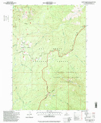
1995 Map of Boston Mountain
USGS Topo · Published 1999About this map
Boston Mountain and its namesake Boston Mountain Lake anchor this high-elevation terrain within the Nez Perce National Forest. The landscape is defined by the intersection of protected wilderness areas and traditional travel routes, most notably the Nez Perce Trail winding through the western portion of the sheet. This 1995 revision reveals a geography focused on remote backcountry management rather than permanent settlement, with numerous benchmarks like BM 7013 and BM 6667 marking ridges and drainages.
Find a feature on this map
33 named features on this map. Tap any name to fly to it.
Don’t see what you’re looking for? This feature index may not catch every label — zoom into the map to look around manually.
Map Details
Editions of this 1995 Boston Mountain Map
This is the sole edition of this map. No revisions or reprints were ever made.
Other maps of this area

1956 · Elk City
USGS Topo · 1:250,000

1960 · Elk City
USGS Topo · 1:250,000

1966 · Green Mtn.
USGS Topo · 1:24,000

1966 · Black Hawk Mtn
USGS Topo · 1:24,000

1966 · Sable Hill
USGS Topo · 1:24,000

1977 · Boston Mtn
USGS Topo · 1:24,000

1978 · Spread Creek Point
USGS Topo · 1:24,000

1978 · Hida Point
USGS Topo · 1:24,000

1978 · Sheep Hill
USGS Topo · 1:24,000

1978 · Trapper Creek
USGS Topo · 1:24,000