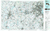
1985 Map of Boston
USGS Topo · Published 1986About this map
The dense urban corridor of eastern Massachusetts is meticulously detailed here, centered on the historic State House and the bustling waterfront of Boston Harbor. This mid-1980s planimetric survey captures the region at a height of post-war suburban maturity and technological growth, stretching from the academic hubs of Harvard University and Mit in Cambridge out toward the emerging tech corridor. The infrastructure of the era is prominent, featuring the Mass Turnpike and the encircling Route 128, which define the commute between settlements like Waltham, Newton, and Lexington.
Find a feature on this map
126 named features on this map. Tap any name to fly to it.
Don’t see what you’re looking for? This feature index may not catch every label — zoom into the map to look around manually.
Map Details
Editions of this 1985 Boston Map
This is the sole edition of this map. No revisions or reprints were ever made.
Other maps of this area

1885 · Abington
USGS Topo · 1:62,500

1885 · Worcester
USGS Topo · 1:62,500

1885 · Middleboro
USGS Topo · 1:62,500

1885 · Taunton
USGS Topo · 1:62,500
1886 · Lawrence
USGS Topo · 1:62,500

1886 · Worcester
USGS Topo · 1:62,500

1886 · Blackstone
USGS Topo · 1:62,500

1886 · Dedham
USGS Topo · 1:62,500

1886 · Lowell
USGS Topo · 1:62,500

1886 · Framingham
USGS Topo · 1:62,500