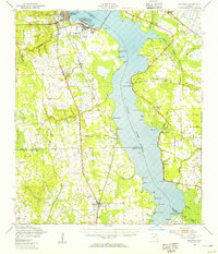
1949 Map of Bostwick
USGS Topo · Published 1955About this map
Green Cove Springs anchors the northwestern shore of the St Johns River in this mid-century survey, a period defined by the convergence of maritime tradition and military expansion. The map details the expansive U S Naval Station and its associated Outlying Field, complete with a Firing Range, signaling the area's strategic importance during and after the war. Southward, the landscape transitions into the smaller rural settlements of Bostwick and Hancock, where the Atlantic Coast Line railroad dictates the pace of commerce and transport.
Find a feature on this map
70 named features on this map. Tap any name to fly to it.
Don’t see what you’re looking for? This feature index may not catch every label — zoom into the map to look around manually.
Map Details
Editions of this 1949 Bostwick Map
This is the sole edition of this map. No revisions or reprints were ever made.
Other maps of this area

1912 · Palatka
USGS Topo · 1:48,000

1915 · Palatka
USGS Topo · 1:62,500

1915 · Interlachen
USGS Topo · 1:48,000

1916 · Interlachen
USGS Topo · 1:62,500

1917 · Orange Park
USGS Topo · 1:62,500

1918 · Middleburg
USGS Topo · 1:62,500

1918 · Orange Park
USGS Topo · 1:62,500

1918 · Palm Valley
USGS Topo · 1:62,500

1937 · Bakersville
USGS Topo · 1:24,000

1937 · Elkton
USGS Topo · 1:24,000