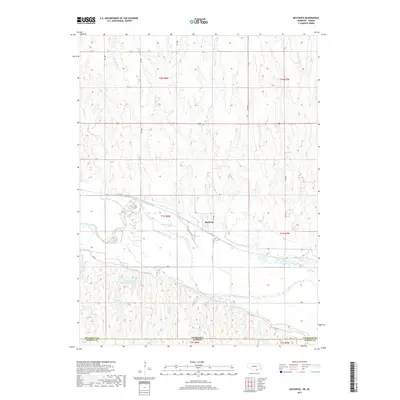
2017 Map of Bostwick
USGS Topo · Published 2017About this map
Bostwick sits at a critical junction of Nebraska's southern border, where the winding Republican River dictates the movement of both water and local boundaries. This 2017 survey illustrates a landscape heavily defined by twentieth-century water management systems designed to support Great Plains agriculture. The Superior Canal and Courtland Canal parallel the river's course, cutting through the terrain to manage irrigation across the Nuckolls Co Jewell Co line. North of the river, a network of drainage creeks including Sand Cr, Beaver Cr, and Cottonwood Cr create a dissected upland that feeds into the river valley. To the southwest, the Johnston and Thompson Reservoir serves as a prominent landmark for local hydrology and land use near the state line. The map's grid of rural roads, such as Rd 3000 and Rd E, provides the framework for this Nebraska-Kansas borderland.
Find a feature on this map
34 named features on this map. Tap any name to fly to it.
Don’t see what you’re looking for? This feature index may not catch every label — zoom into the map to look around manually.
Map Details
Editions of this 2017 Bostwick Map
This is the sole edition of this map. No revisions or reprints were ever made.
Other maps of this area

1894 · Mankato
USGS Topo · 1:125,000

1898 · Superior
USGS Topo · 1:125,000

1955 · Grand Island
USGS Topo · 1:250,000

1955 · Beloit
USGS Topo · 1:250,000

1957 · Grand Island
USGS Topo · 1:250,000

1958 · Grand Island
USGS Topo · 1:250,000

1959 · Beloit
USGS Topo · 1:250,000
1969 · North Branch
USGS Topo · 1:24,000
1969 · Mankato NW
USGS Topo · 1:24,000
1969 · Webber
USGS Topo · 1:24,000