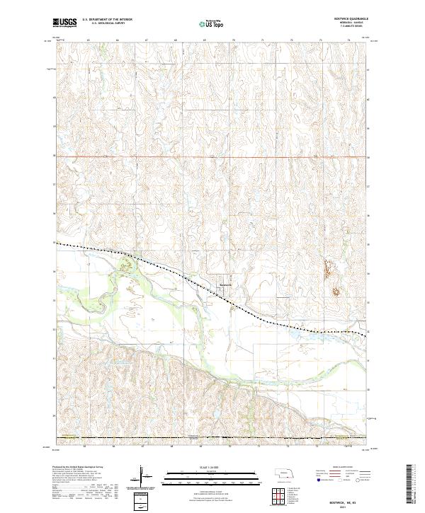
2021 Map of Bostwick
USGS Topo · Published 2021About this map
The Republican River serves as the central geographic feature of this section of Nuckolls County, defining the agricultural character of the landscape near the small settlement of Bostwick. This modern survey reveals a highly engineered water management system vital to local farming, including the Superior Canal and Courtland Canal, which flank the river valley. The terrain is marked by numerous drainage systems such as Beaver Cr, Cottonwood Cr, and Sand Cr, which cut through the uplands before joining the main river channel. Along the southern border, the Nebraska-Kansas state line intersects with Nuckolls and Jewell County boundaries. Localized water storage is evident at the Johnston and Thompson Reservoir and Gibson Reservoir, illustrating how water resources are captured and diverted across the plains south of Highway 136.
Find a feature on this map
31 named features on this map. Tap any name to fly to it.
Don’t see what you’re looking for? This feature index may not catch every label — zoom into the map to look around manually.
Map Details
Editions of this 2021 Bostwick Map
This is the sole edition of this map. No revisions or reprints were ever made.
Other maps of this area

1894 · Mankato
USGS Topo · 1:125,000

1898 · Superior
USGS Topo · 1:125,000

1955 · Grand Island
USGS Topo · 1:250,000

1955 · Beloit
USGS Topo · 1:250,000

1957 · Grand Island
USGS Topo · 1:250,000

1958 · Grand Island
USGS Topo · 1:250,000

1959 · Beloit
USGS Topo · 1:250,000
1969 · North Branch
USGS Topo · 1:24,000
1969 · Mankato NW
USGS Topo · 1:24,000
1969 · Webber
USGS Topo · 1:24,000