1943 Map of Botsford
USGS Topo · Published 1943About this map
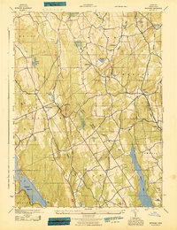
Botsford serves as a key crossroads during the early 1940s, situated where the Bridgeport (Branch) rail line and the Botsford Sta intersect with the local road network. This era shows a landscape transitioning between established agricultural townships and the development of major water resources. The southern portion of the sheet is dominated by the newly formed Saugatuck Reservoir and Easton Lake, which significantly altered the local drainage patterns of the Aspetuck River and Little River.
Find a feature on this map
33 named features on this map. Tap any name to fly to it.
Don’t see what you’re looking for? This feature index may not catch every label — zoom into the map to look around manually.
Map Details
Editions of this 1943 Botsford Map
This is the sole edition of this map. No revisions or reprints were ever made.
Other maps of this area

1889 · Derby
USGS Topo · 1:62,500

1891 · Bridgeport
USGS Topo · 1:62,500

1891 · Derby
USGS Topo · 1:62,500

1892 · Danbury
USGS Topo · 1:62,500

1892 · Norwalk
USGS Topo · 1:62,500

1893 · Bridgeport
USGS Topo · 1:62,500

1893 · Norwalk
USGS Topo · 1:62,500

1893 · Derby
USGS Topo · 1:62,500

1915 · Danbury
USGS Topo · 1:62,500

1920 · Bridgeport
USGS Topo · 1:62,500