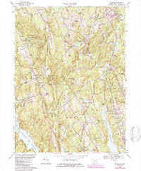
1969 Map of Botsford
USGS Topo · Published 1987About this map
The hills of Fairfield County are captured here in a period of late-century growth, where the rural character of southwestern Connecticut meets increasing residential development. Huntington State Park dominates the northwest, preserving a landscape of ponds like North Pond and Lily Pond amidst the rising terrain of Sunset Hill. To the east, the Penn Central railroad passes through the industrial node at Botsford, where numerous Gravel Pits indicate active local quarrying.
Find a feature on this map
109 named features on this map. Tap any name to fly to it.
Don’t see what you’re looking for? This feature index may not catch every label — zoom into the map to look around manually.
Map Details
Editions of this 1969 Botsford Map
4 editions found
Other maps of this area

1889 · Derby
USGS Topo · 1:62,500

1891 · Bridgeport
USGS Topo · 1:62,500

1891 · Derby
USGS Topo · 1:62,500

1892 · Danbury
USGS Topo · 1:62,500

1892 · Norwalk
USGS Topo · 1:62,500

1893 · Bridgeport
USGS Topo · 1:62,500

1893 · Norwalk
USGS Topo · 1:62,500

1893 · Derby
USGS Topo · 1:62,500

1915 · Danbury
USGS Topo · 1:62,500

1920 · Bridgeport
USGS Topo · 1:62,500