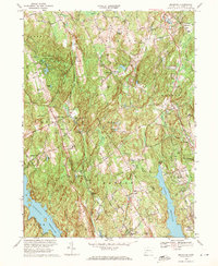
1969 Map of Botsford
USGS Topo · Published 1971About this map
The Huntington State Park and the expansive Saugatuck Reservoir anchor this landscape, reflecting a mid-century Fairfield County defined by watershed protection and suburban expansion. At this stage in the late 1960s, the rural character remains evident in the numerous small settlements like Redding Ridge, Stepney, and Botsford, while the Penn Central rail line cuts through the northeastern corner near Middle Gate Sch.
Find a feature on this map
93 named features on this map. Tap any name to fly to it.
Don’t see what you’re looking for? This feature index may not catch every label — zoom into the map to look around manually.
Map Details
Editions of this 1969 Botsford Map
4 editions found
Other maps of this area

1889 · Derby
USGS Topo · 1:62,500

1891 · Bridgeport
USGS Topo · 1:62,500

1891 · Derby
USGS Topo · 1:62,500

1892 · Danbury
USGS Topo · 1:62,500

1892 · Norwalk
USGS Topo · 1:62,500

1893 · Bridgeport
USGS Topo · 1:62,500

1893 · Norwalk
USGS Topo · 1:62,500

1893 · Derby
USGS Topo · 1:62,500

1915 · Danbury
USGS Topo · 1:62,500

1920 · Bridgeport
USGS Topo · 1:62,500