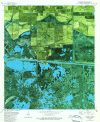
1982 Map of Boudreaux Lake
USGS Topo · Published 1982About this map
Gibbstown serves as a small focal point in this coastal landscape, situated precisely where the north-south transport route meets the Intracoastal Waterway. This 1982 orthophotomap provides a clear view of the Louisiana marshland transition, where agricultural fields in the north give way to the expansive wetlands of Cameron Parish. The terrain is defined by a complex network of water bodies, including Boudreaux Lake and Broussard Lake, interspersed with higher ground such as Savane Neuville Island. Human activity is recorded through specialized features like Granger Cem and the various Oil Tanks and Drill Holes that signal the region's energy economy. This edition, based on 1975 aerial photography, documents the exact footprint of drainage canals and elevated roads used to navigate this fluid environment.
Find a feature on this map
13 named features on this map. Tap any name to fly to it.
Don’t see what you’re looking for? This feature index may not catch every label — zoom into the map to look around manually.
Map Details
Editions of this 1982 Boudreaux Lake Map
2 editions found
Other maps of this area

1932 · Lake Charles SW
USGS Topo · 1:31,680

1932 · Lake Charles SE
USGS Topo · 1:31,680

1934 · Lake Misere
USGS Topo · 1:24,000

1934 · Sweet Lake
USGS Topo · 1:24,000

1934 · Grand Bayou
USGS Topo · 1:24,000

1934 · Boudreaux Lake
USGS Topo · 1:24,000

1935 · Sweet Lake
USGS Topo · 1:31,680

1935 · Lake Misere
USGS Topo · 1:31,680

1935 · Boudreaux Lake
USGS Topo · 1:31,680

1935 · Grand Bayou
USGS Topo · 1:31,680