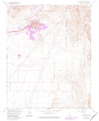
1958 Map of Boulder City
USGS Topo · Published 1983About this map
Boulder City stands as a distinct planned community in the desert, established to house the workforce that built the nearby Hoover Dam. This topographic record shows the town's mid-century footprint, featuring the High School, Memorial Park, and the Municipal Airport on its western edge. To the north and west, the landscape is defined by the Mountains and the drainage patterns of Hemenway Wash and Bootleg Wash. The presence of an Old Railroad Grade and the Boulder City municipal boundary illustrates the town’s early infrastructure and growth constraints. To the east, the terrain rises into the Eldorado Mountains, falling away toward the Lake Mead National Recreation Area. These borders emphasize the town's unique position as a gateway to the federally managed lands and waters of the Colorado River system.
Find a feature on this map
29 named features on this map. Tap any name to fly to it.
Don’t see what you’re looking for? This feature index may not catch every label — zoom into the map to look around manually.
Map Details
Editions of this 1958 Boulder City Map
Other maps of this area

1886 · Camp Mohave
USGS Topo · 1:250,000

1886 · Saint Thomas
USGS Topo · 1:250,000

1892 · Camp Mohave
USGS Topo · 1:250,000

1893 · Saint Thomas
USGS Topo · 1:250,000

1926 · Nelson
USGS Topo · 1:96,000

1926 · Boulder Canyon
USGS Topo · 1:96,000

1942 · Camp Mohave
USGS Topo · 1:250,000

1947 · Kingman
USGS Topo · 1:250,000

1948 · Kingman
USGS Topo · 1:250,000

1952 · Henderson
USGS Topo · 1:62,500