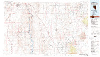
1983 Map of Boulder City
USGS Topo · Published 1983About this map
The Colorado River system, punctuated by the massive impoundments of Lake Mead and Lake Mohave, forms the central artery of this 1983 survey. This arid landscape is defined by the stark transition from the Black Mountains to the broad expanses of the Detrital Valley and Hualapai Valley. Beyond the established hub of Boulder City, the map reveals a heavy concentration of mining history in the surrounding ranges, from the King Tut Placer Mine in the north to the Nevada Eagle Mine and Dice Gold Mine further south.
Find a feature on this map
85 named features on this map. Tap any name to fly to it.
Don’t see what you’re looking for? This feature index may not catch every label — zoom into the map to look around manually.
Map Details
Editions of this 1983 Boulder City Map
2 editions found
Other maps of this area

1886 · Diamond Creek
USGS Topo · 1:250,000

1886 · Camp Mohave
USGS Topo · 1:250,000

1886 · Saint Thomas
USGS Topo · 1:250,000

1886 · Mt. Trumbull
USGS Topo · 1:250,000

1892 · Diamond Creek
USGS Topo · 1:250,000

1892 · Mt. Trumbull
USGS Topo · 1:250,000

1892 · Camp Mohave
USGS Topo · 1:250,000

1893 · Saint Thomas
USGS Topo · 1:250,000

1907 · Las Vegas
USGS Topo · 1:250,000

1908 · Las Vegas
USGS Topo · 1:250,000