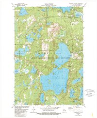
1981 Map of Boulder Junction
USGS Topo · Published 1989About this map
Boulder Junction serves as the focal point for this lake-strewn landscape in Northern Wisconsin, surrounded by the dense reaches of the Northern Highland-American Legion State Forest. The map captures the area's transition into a premier recreation destination, documented by the numerous shoreline developments at Camp Manito-wish, Camp Fiesta, and several public campgrounds. Significant water bodies like Trout Lake, Big Muskellunge Lake, and the Manitowish River dominate the topography, illustrating the region's post-logging identity. Cultural markers are visible in the Pines Cem and the State Forest Headquarters, while the presence of a Lookout Tower and various waysides like Wayside Park highlight the managed nature of the timberlands. The intricate network of smaller lakes, including Jag Lake and Little Rice Lake, points to the complex glacial drainage patterns that define this section of Vilas County.
Find a feature on this map
47 named features on this map. Tap any name to fly to it.
Don’t see what you’re looking for? This feature index may not catch every label — zoom into the map to look around manually.
Map Details
Editions of this 1981 Boulder Junction Map
2 editions found
Other maps of this area

1938 · Minocqua
USGS Topo · 1:48,000

1938 · Lac Du Flambeau
USGS Topo · 1:48,000

1939 · Trout Lake
USGS Topo · 1:48,000

1939 · Lac Du Flambeau
USGS Topo · 1:48,000

1939 · Winchester
USGS Topo · 1:48,000

1946 · Winchester
USGS Topo · 1:48,000

1946 · Minocqua
USGS Topo · 1:48,000

1946 · Lac Du Flambeau
USGS Topo · 1:48,000

1946 · Trout Lake
USGS Topo · 1:48,000

1949 · Trout Lake
USGS Topo · 1:48,000