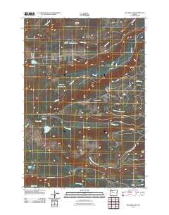
2011 Map of Boulder Lake
USGS Topo · Published 2011About this map
Lookout Butte and Badger Butte dominate this high-elevation landscape in the Cascades, where a complex network of forest service and Bureau of Indian Affairs roads navigates a series of drainages and volcanic features. The water system is defined by the three forks of Boulder Creek and the southern flow of Shitike Creek, which carve through the terrain. Evidence of the region's geological character is found in the Cinder Cone near Blue Lake. Recreational access is centered around the Trout Lake Campground near Trout Lake, while the eastern portion of the map transitions into the administrative road networks of the Warm Springs area, including Bia 6 RD and Bia 44 RD. Smaller landmarks like Owl Spring and Peters Pasture provide specific points of interest for those tracking historical land use and named backcountry locations.
Find a feature on this map
37 named features on this map. Tap any name to fly to it.
Don’t see what you’re looking for? This feature index may not catch every label — zoom into the map to look around manually.
Map Details
Editions of this 2011 Boulder Lake Map
This is the sole edition of this map. No revisions or reprints were ever made.
Other maps of this area

1927 · Mt. Jefferson
USGS Topo · 1:125,000

1930 · Mt. Jefferson
USGS Topo · 1:125,000

1955 · Bend
USGS Topo · 1:250,000

1957 · Bend
USGS Topo · 1:250,000

1958 · Bend
USGS Topo · 1:250,000

1961 · Whitewater River
USGS Topo · 1:62,500

1961 · Fort Butte
USGS Topo · 1:62,500
1961 · Mt. Jefferson
USGS Topo · 1:62,500
1961 · Breitenbush Hot Springs
USGS Topo · 1:62,500
1983 · Madras
USGS Topo · 1:100,000