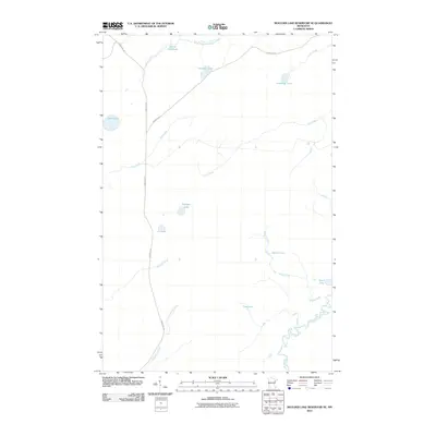
2010 Map of Boulder Lake Reservoir NE
USGS Topo · Published 2010About this map
The Cloquet River meanders through the southeastern corner of this Saint Louis County landscape, while the South Branch Whiteface River defines the northern edge. This area of Ault Township is characterized by a dense network of waterways and glacial lakes, including Sullivan Lake, American Lake, and Schinn Lake. The transportation network is anchored by the historic Vermilion Trl, which cuts a nearly straight path through the western half of the territory, intersecting with Brimson Rd. Numerous smaller drainages like Masse Creek, Civet Creek, and Humphrey Creek weave between the wetlands. The distribution of these water bodies and trails reflects the northern Minnesota wilderness as it was documented by the Geological Survey in the early 21st century, providing a clear view of the drainage patterns and access points into this part of the Arrowhead region.
Find a feature on this map
20 named features on this map. Tap any name to fly to it.
Don’t see what you’re looking for? This feature index may not catch every label — zoom into the map to look around manually.
Map Details
Editions of this 2010 Boulder Lake Reservoir NE Map
This is the sole edition of this map. No revisions or reprints were ever made.
Other maps of this area

1953 · Boulder Lake Reservoir
USGS Topo · 1:24,000

1954 · Barrs Lake
USGS Topo · 1:24,000

1954 · Thompson Lake
USGS Topo · 1:24,000

1954 · Two Harbors
USGS Topo · 1:250,000

1954 · Hibbing
USGS Topo · 1:250,000

1956 · Pequaywan Lake
USGS Topo · 1:24,000

1957 · Two Harbors
USGS Topo · 1:250,000

1957 · Hibbing
USGS Topo · 1:250,000

1957 · Brimson
USGS Topo · 1:62,500

1957 · Markham
USGS Topo · 1:62,500