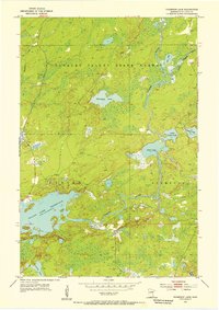
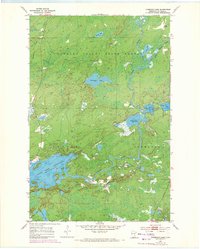
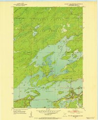
1954 Map of Thompson Lake
USGS Topo · Published 1955About this map
The Cloquet Valley State Forest dominates the northern reaches of this mid-century survey, showcasing a landscape of dense timber and complex hydrology. The Cloquet River and the Little Cloquet River wind through the terrain, feeding into a series of interconnected water bodies such as Alden Lake, Little Alden Lake, and Thompson Lake. To the south, the massive expanse of the Island Lake Reservoir defines the local topography, with its jagged shoreline and Numerous islands reflecting its role in regional water management. Sparse human activity is evident through scattered markers like the Gravel Pit and primitive roads that navigate the townships of Gnesen and Normann. This 1950s documentation provides a clear view of the area before modern development, capturing the essential character of the North Woods and its reliance on the river systems for both drainage and resource extraction.
Find a feature on this map
18 named features on this map. Tap any name to fly to it.
Don’t see what you’re looking for? This feature index may not catch every label — zoom into the map to look around manually.
Map Details
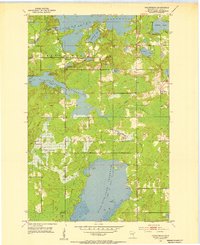
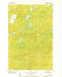
Editions of this 1954 Thompson Lake Map
3 editions found

Other maps of this area

1895 · Duluth
USGS Topo · 1:62,500
1953 · French River
USGS Topo · 1:24,000
1953 · Arnold
USGS Topo · 1:24,000
1953 · Boulder Lake Reservoir
USGS Topo · 1:24,000
1953 · Fredenberg
USGS Topo · 1:24,000

1953 · Duluth
USGS Topo · 1:62,500

1953 · Ashland
USGS Topo · 1:250,000

1953 · Duluth
USGS Topo · 1:250,000
1954 · Barrs Lake
USGS Topo · 1:24,000

1954 · Two Harbors
USGS Topo · 1:250,000
Featured Places
- Gnesen Township, MN
- Marion Lake, MN
- Normanna Township, MN
- North Star Township, MN
- Saint Louis County, MN