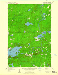
1954 Map of Thompson Lake
USGS Topo · Published 1960About this map
The Cloquet Valley State Forest dominates this northern landscape, where the winding Cloquet River and its tributaries define the regional geography. Surveyed in the mid-1950s, the map reveals a wilderness area heavily shaped by water management and resource extraction. The vast Island Lake Reservoir occupies the southern section of the quadrangle, with its shoreline intricately carved by the surrounding terrain. To the north, a series of connected waterways including Alden Lake, Little Alden Lake, and Spring Lake create a complex aquatic network. Human activity is sparsely represented, primarily through a network of unimproved dirt roads and a lone Gravel Pit near the reservoir, illustrating the era's focus on timber and water resources rather than dense settlement. The topography is further marked by the townships of Gnesen and Normann.
Find a feature on this map
18 named features on this map. Tap any name to fly to it.
Don’t see what you’re looking for? This feature index may not catch every label — zoom into the map to look around manually.
Map Details
Editions of this 1954 Thompson Lake Map
3 editions found
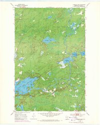
Other maps of this area

1895 · Duluth
USGS Topo · 1:62,500

1953 · French River
USGS Topo · 1:24,000

1953 · Arnold
USGS Topo · 1:24,000

1953 · Boulder Lake Reservoir
USGS Topo · 1:24,000

1953 · Fredenberg
USGS Topo · 1:24,000

1953 · Duluth
USGS Topo · 1:62,500

1953 · Ashland
USGS Topo · 1:250,000

1953 · Duluth
USGS Topo · 1:250,000

1954 · Barrs Lake
USGS Topo · 1:24,000

1954 · Thompson Lake
USGS Topo · 1:24,000
Featured Places
- Gnesen Township, MN
- Marion Lake, MN
- Normanna Township, MN
- North Star Township, MN
- Saint Louis County, MN