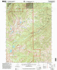
2001 Map of Boulder Peak
USGS Topo · Published 2004About this map
Klamath National Forest dominates this high-altitude landscape, where the Marble Mountain Wilderness protects a dense cluster of alpine lakes and meadows. The area is defined by its dramatic relief, anchored by the summit of Boulder Peak and a series of glacial cirques containing Isinglass Lake, Cliff Lake, and Campbell Lake. The drainage patterns are clearly established by Shackleford Creek and the Shelly Fork Kidder Creek, which flow through heavily timbered valleys. Hikers and researchers can trace the precise 2001 alignment of the Pacific Crest Nat Scenic Trail as it traverses the western ridges, passing through Muse Meadow and Summit Meadow. The presence of numerous named springs and high-altitude pastures like Sniktaw Meadow indicates the historical importance of water sources and summer grazing in this part of Siskiyou County.
Find a feature on this map
48 named features on this map. Tap any name to fly to it.
Don’t see what you’re looking for? This feature index may not catch every label — zoom into the map to look around manually.
Map Details
Editions of this 2001 Boulder Peak Map
This is the sole edition of this map. No revisions or reprints were ever made.
Other maps of this area

1886 · Shasta
USGS Topo · 1:250,000

1894 · Shasta
USGS Topo · 1:250,000

1914 · Seiad
USGS Topo · 1:125,000

1922 · Seiad
USGS Topo · 1:125,000

1923 · Sawyers Bar
USGS Topo · 1:125,000

1931 · Etna
USGS Topo · 1:96,000

1932 · Yreka
USGS Topo · 1:96,000

1934 · Etna
USGS Topo · 1:125,000

1939 · Yreka
USGS Topo · 1:125,000

1948 · Weed
USGS Topo · 1:250,000