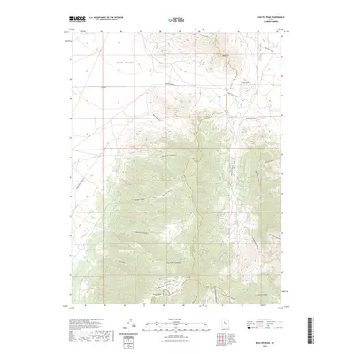
2023 Map of Boulter Peak
USGS Topo · Published 2023About this map
East Tintic Mountains dominate this high-desert landscape, where three Utah counties—Tooele, Utah, and Juab—converge near Boulter Peak. The area serves as a significant drainage divide between the northern Rush Valley and the eastern Cedar Valley. This modern survey details a network of canyon access points and historical transit corridors, including Twelvemile Pass, which has long provided a natural break in the terrain for travel between the valleys. The prominence of features like Miners Canyon and Black Rock Canyon suggests a history of resource exploration in these highlands. On the southern slopes, Dry Lake sits as a seasonal catch basin, while numerous canyon roads like Barlow Canyon Rd and Broad Canyon Rd track through the deep relief of Gardison Ridge and County Line Ridge.
Find a feature on this map
36 named features on this map. Tap any name to fly to it.
Don’t see what you’re looking for? This feature index may not catch every label — zoom into the map to look around manually.
Map Details
Editions of this 2023 Boulter Peak Map
This is the sole edition of this map. No revisions or reprints were ever made.
Other maps of this area

1885 · Sevier Desert
USGS Topo · 1:250,000

1885 · Tooele Valley
USGS Topo · 1:250,000

1947 · Fivemile Pass
USGS Topo · 1:62,500

1947 · Allens Ranch
USGS Topo · 1:24,000

1947 · Boulter Peak
USGS Topo · 1:24,000

1947 · Goshen Pass
USGS Topo · 1:24,000

1949 · Eureka
USGS Topo · 1:24,000

1949 · Allens Ranch
USGS Topo · 1:24,000

1949 · Fivemile Pass
USGS Topo · 1:24,000

1949 · Goshen Pass
USGS Topo · 1:24,000