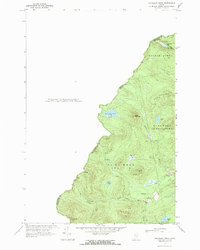
1970 Map of Boundary Pond
USGS Topo · Published 1973About this map
The Canada-United States border defines this remote stretch of the Maine woods, where the jagged international line separates Franklin County from Frontenac County, Quebec. Significant for its early 20th-century surveying history, the area includes benchmarks like Lowelltown North Base and Lowelltown South Base, established as the boundary was formalized through the rugged highlands. The topography is dominated by high summits such as Dome Mountain and Clear Pond Mtn, with drainage flowing through the Moose River and the Lowelltown Branch. Settlement is sparse, limited primarily to the outpost at Lowelltown and the Dome Mtn Camps near the edge of Boundary Pond. The presence of the Canadian Pacific Road cutting through the southern townships of Beattie and Lowelltown highlights the historical importance of rail-and-road corridors in accessing these deep timberlands.
Find a feature on this map
28 named features on this map. Tap any name to fly to it.
Don’t see what you’re looking for? This feature index may not catch every label — zoom into the map to look around manually.
Map Details
Editions of this 1970 Boundary Pond Map
This is the sole edition of this map. No revisions or reprints were ever made.
Other maps of this area

1928 · Chain Lakes
USGS Topo · 1:48,000

1928 · Skinner
USGS Topo · 1:48,000

1931 · Skinner
USGS Topo · 1:62,500

1932 · Arnold Pond
USGS Topo · 1:48,000

1932 · Chain Lakes
USGS Topo · 1:62,500

1935 · Chain Lakes
USGS Topo · 1:62,500

1935 · Arnold Pond
USGS Topo · 1:62,500

1949 · Jackman
USGS Topo · 1:250,000
1951 · Chain Lakes
USGS Topo · 1:50,000

1963 · Jackman
USGS Topo · 1:250,000