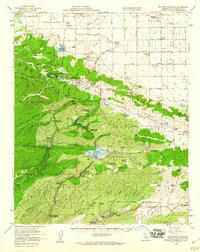
1958 Map of Bouquet Reservoir
USGS Topo · Published 1960About this map
Bouquet Reservoir and the Fairmont Reservoir dominate the hydrology of this high desert and mountain landscape during the late 1950s. The map illustrates a critical period of water management and infrastructure development in Los Angeles County, featuring the Fairmont Reservoir Intake Tower and San Francisquito Powerhouse No 2. Along the San Andreas Fault zone, the natural sag ponds of Lake Hughes and Elizabeth Lake provide the backdrop for established mountain communities.
Find a feature on this map
99 named features on this map. Tap any name to fly to it.
Don’t see what you’re looking for? This feature index may not catch every label — zoom into the map to look around manually.
Map Details
Editions of this 1958 Bouquet Reservoir Map
2 editions found
Other maps of this area

1900 · Tujunga
USGS Topo · 1:62,500

1900 · Fernando
USGS Topo · 1:62,500

1901 · Southern California Sheet No. 1
USGS Topo · 1:250,000

1903 · Tejon
USGS Topo · 1:125,000

1903 · Camulos
USGS Topo · 1:125,000

1903 · Santa Susana
USGS Topo · 1:62,500

1904 · Southern California Sheet No. 1
USGS Topo · 1:250,000

1915 · Elizabeth Lake
USGS Topo · 1:125,000

1917 · Elizabeth Lake
USGS Topo · 1:125,000

1929 · Saugus
USGS Topo · 1:24,000