
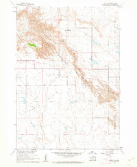
1952 Map of Bouquet Table
USGS Topo · Published 1952About this map
Pine Ridge Indian Reservation and the Badlands National Monument meet in this 1952 study of southwestern South Dakota. The topography is dominated by the massive plateau of Bouquet Table, which divides the drainage systems of Cain Creek and Clifford Creek before they reach the White River. This map illustrates the intersection of federal lands and local life during the early 1950s, highlighting the Reservation Boundary as it follows the section lines between Pennington and Shannon counties.
Find a feature on this map
12 named features on this map. Tap any name to fly to it.
Don’t see what you’re looking for? This feature index may not catch every label — zoom into the map to look around manually.
Map Details
Editions of this 1952 Bouquet Table Map
This is the sole edition of this map. No revisions or reprints were ever made.
Other maps of this area

1950 · Conata
USGS Topo · 1:24,000

1950 · Conata SW
USGS Topo · 1:24,000

1950 · Imlay SW
USGS Topo · 1:24,000

1950 · Imlay
USGS Topo · 1:24,000

1950 · Imlay SE
USGS Topo · 1:24,000

1950 · Bouquet Table
USGS Topo · 1:24,000

1952 · Conata
USGS Topo · 1:24,000

1955 · Hot Springs
USGS Topo · 1:250,000

1960 · Quinn Table SE
USGS Topo · 1:24,000
1960 · Wall SW
USGS Topo · 1:24,000