
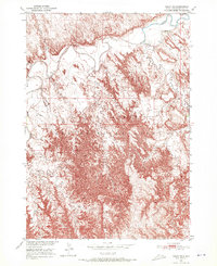
1950 Map of Imlay SE
USGS Topo · Published 1952About this map
The White River winds through the northern portion of this landscape within the Pine Ridge Indian Reservation, creating a complex network of meanders and riverbanks. Surveyed in 1950, the area shows a distinct contrast between the river valley and the deeply eroded breaks that characterize the terrain. Local landmarks are sparse but significant for genealogy and local history, notably St Barbaras Ch situated near the river's path in the northeast. The drainage system is further defined by several named tributaries, including Medicine Root Creek and Clifford Creek, which cut through the southern uplands. This topographic study was produced as part of a larger federal initiative for the development of the Missouri River Basin, documenting the hydrologic and physical state of the reservation lands before significant modern changes.
Find a feature on this map
8 named features on this map. Tap any name to fly to it.
Don’t see what you’re looking for? This feature index may not catch every label — zoom into the map to look around manually.
Map Details
Editions of this 1950 Imlay SE Map
2 editions found
Other maps of this area

1950 · Conata
USGS Topo · 1:24,000

1950 · Conata SW
USGS Topo · 1:24,000

1950 · Imlay SW
USGS Topo · 1:24,000

1950 · Imlay
USGS Topo · 1:24,000

1950 · Bouquet Table
USGS Topo · 1:24,000

1951 · Sharps Corner
USGS Topo · 1:24,000

1952 · Bouquet Table
USGS Topo · 1:24,000

1952 · Conata
USGS Topo · 1:24,000

1955 · Hot Springs
USGS Topo · 1:250,000

1981 · Wall
USGS Topo · 1:100,000