
1950 Map of Conata
USGS Topo · Published 1950About this map
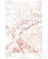
Pine Ridge Indian Reservation occupies the southern half of this 1950 survey, where the White River carves a winding path through the Badlands landscape. To the north, the corridor of the Chicago Milwaukee St Paul and Pacific railroad serves the small settlement of Conata, providing a vital transit link across the prairie. The map captures an era of early natural resource exploration, evidenced by an Oil Well located north of the river near Kelier Butte. The terrain is defined by prominent high points such as Castle Butte and Hurley Butte, while Redwater Creek drains the reservation lands to the south. This survey documents the intersection of indigenous lands, early industrial infrastructure, and the distinct geological formations of Pennington and Shannon Counties.
Find a feature on this map
13 named features on this map. Tap any name to fly to it.
Don’t see what you’re looking for? This feature index may not catch every label — zoom into the map to look around manually.
Map Details
Editions of this 1950 Conata Map
2 editions found
Other maps of this area

1950 · Conata SW
USGS Topo · 1:24,000

1950 · Imlay SE
USGS Topo · 1:24,000

1950 · Bouquet Table
USGS Topo · 1:24,000

1952 · Conata NE
USGS Topo · 1:24,000

1952 · Bouquet Table
USGS Topo · 1:24,000

1952 · Conata SE
USGS Topo · 1:24,000

1952 · Conata
USGS Topo · 1:24,000

1955 · Hot Springs
USGS Topo · 1:250,000

1960 · Wall SE
USGS Topo · 1:24,000

1960 · Quinn Table SE
USGS Topo · 1:24,000