
1960 Map of Wall SE
USGS Topo · Published 1961About this map
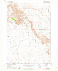
Badlands National Monument dominates the southern landscape of this 1960 survey, where the eroded formations of the Wall transition into the high plains. The boundary between Pennington and Jackson counties bisects the terrain, illustrating the sparse settlement patterns of the era. Evidence of community life is found along the creek valleys, specifically the Big Foot Sch and Big Foot Ch, which served the local ranching families near the northern edge of the monument.
Find a feature on this map
10 named features on this map. Tap any name to fly to it.
Don’t see what you’re looking for? This feature index may not catch every label — zoom into the map to look around manually.
Map Details
Editions of this 1960 Wall SE Map
This is the sole edition of this map. No revisions or reprints were ever made.
Other maps of this area

1950 · Conata
USGS Topo · 1:24,000

1950 · Interior
USGS Topo · 1:24,000

1952 · Conata NE
USGS Topo · 1:24,000

1952 · Conata
USGS Topo · 1:24,000

1955 · Hot Springs
USGS Topo · 1:250,000

1955 · Martin
USGS Topo · 1:250,000

1958 · Martin
USGS Topo · 1:250,000

1960 · Wall
USGS Topo · 1:24,000

1960 · Cottonwood SW
USGS Topo · 1:24,000
1960 · Wall SW
USGS Topo · 1:24,000