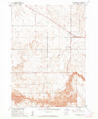
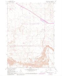
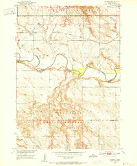
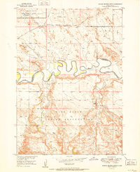
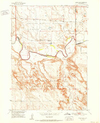
1960 Map of Cottonwood SW
USGS Topo · Published 1962About this map
Badlands National Monument defines the southern half of this South Dakota landscape, where the deeply eroded terrain meets the rolling prairie. At the northern edge of this geological transition lies Cactus Flats, serving as a gateway point near the intersection of major roads and the ridge of Big Foot Hill. The map documents a landscape of dramatic elevation changes and sparse water sources, primarily defined by the drainage of Big Buffalo Creek and Rake Creek. A localized industrial footprint is visible at the Gravel Pit near the center of the sheet, while the southern reaches include Cedar Pass, a significant natural corridor through the badlands formations. The network of unimproved roads and a Jeep Trail suggests a rugged, sparsely populated environment in the early 1960s, primarily managed for conservation and limited transit between Interior and the surrounding plains.
Find a feature on this map
9 named features on this map. Tap any name to fly to it.
Don’t see what you’re looking for? This feature index may not catch every label — zoom into the map to look around manually.
Map Details
Editions of this 1960 Cottonwood SW Map
2 editions found
Other maps of this area
1950 · Interior
USGS Topo · 1:24,000
1951 · School Section Butte
USGS Topo · 1:24,000
1952 · Conata NE
USGS Topo · 1:24,000

1955 · Hot Springs
USGS Topo · 1:250,000

1955 · Martin
USGS Topo · 1:250,000

1958 · Martin
USGS Topo · 1:250,000

1960 · Wall SE
USGS Topo · 1:24,000
1961 · Cottonwood
USGS Topo · 1:24,000
1961 · Cottonwood NE
USGS Topo · 1:24,000
1961 · Wall NE
USGS Topo · 1:24,000