
1950 Map of Interior
USGS Topo · Published 1952About this map
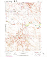
Interior sits at the northern edge of the Pine Ridge Indian Reservation, where the prairie landscape transitions into the sharp breaks of the Badlands National Monument. This 1950 field-checked survey reveals a critical junction between the Chicago Milwaukee St Paul and Pacific railroad and the winding course of the White River. The river forms a natural boundary between Jackson and Washabaugh counties, cutting a wide, light-yellow path across the center of the sheet. Further south, the high ground of Pine Ridge is dissected by seasonal drainages like Lost Dog Creek and Sixteenmile Creek. Near the southern edge, the isolated Lone Tree Sch. serves as a lone marker of educational infrastructure in this rural cattle-country landscape, while the Monument Hdqrs at the northern border anchors the early development of the national park lands.
Find a feature on this map
13 named features on this map. Tap any name to fly to it.
Don’t see what you’re looking for? This feature index may not catch every label — zoom into the map to look around manually.
Map Details
Editions of this 1950 Interior Map
2 editions found
Other maps of this area

1950 · Interior SE
USGS Topo · 1:24,000

1950 · Potato Creek
USGS Topo · 1:24,000

1951 · School Section Butte
USGS Topo · 1:24,000

1952 · Conata NE
USGS Topo · 1:24,000

1952 · Conata SE
USGS Topo · 1:24,000

1955 · Hot Springs
USGS Topo · 1:250,000

1955 · Martin
USGS Topo · 1:250,000

1958 · Martin
USGS Topo · 1:250,000

1960 · Wall SE
USGS Topo · 1:24,000

1960 · Cottonwood SW
USGS Topo · 1:24,000