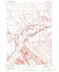
1950 Map of Conata
USGS Topo · Published 1972About this map
Pine Ridge Indian Reservation occupies the southern half of this landscape, its boundary following the winding course of the White River. The northern section is dominated by the high plateaus of Hurley Butte and Kelley Butte, which overlook the vast drainage system. This 1950 field-checked survey captures the area at a time when the Chicago Milwaukee St Paul and Pacific railroad served as the primary east-west artery, with the small settlement of Conata positioned along its tracks. The transition from the rugged badlands terrain to the river valley is marked by drainage features like Redwater Creek, while a lone Oil Well signifies early industrial exploration in this remote portion of South Dakota. The map meticulously delineates the county lines where Pennington, Shannon, and Washabaugh meet, providing a clear record of administrative boundaries during the mid-century era.
Find a feature on this map
13 named features on this map. Tap any name to fly to it.
Don’t see what you’re looking for? This feature index may not catch every label — zoom into the map to look around manually.
Map Details
Editions of this 1950 Conata Map
2 editions found
Other maps of this area

1950 · Conata
USGS Topo · 1:24,000

1950 · Conata SW
USGS Topo · 1:24,000

1950 · Imlay SE
USGS Topo · 1:24,000

1950 · Bouquet Table
USGS Topo · 1:24,000

1952 · Conata NE
USGS Topo · 1:24,000

1952 · Bouquet Table
USGS Topo · 1:24,000

1952 · Conata SE
USGS Topo · 1:24,000

1952 · Conata
USGS Topo · 1:24,000

1955 · Hot Springs
USGS Topo · 1:250,000

1960 · Wall SE
USGS Topo · 1:24,000