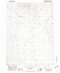
1982 Map of Bowden Waterhole
USGS Topo · Published 1983About this map
Blue Mountain dominates the northern reaches of this high-desert landscape in Malheur County, where water management is the defining feature of the terrain. The presence of Ninety Five Reservoir and the namesake Bowden Waterhole underscores the area's importance for livestock and range management in the early 1980s. Vital water sources are scattered throughout the drainage systems of Oregon Canyon Creek and Jackson Creek, including the McDermott Well No. 1 and McDermott Well No. 2. This survey records a landscape shaped by both natural drainage and human infrastructure, evidenced by a Single Wood Pole Transmission Line and a remote Airstrip that provided access to this corner of the Oregon high country. Researchers can trace the network of unimproved roads and trails that connected these water points and small industrial sites like the Borrow Pit.
Find a feature on this map
15 named features on this map. Tap any name to fly to it.
Don’t see what you’re looking for? This feature index may not catch every label — zoom into the map to look around manually.
Map Details
Editions of this 1982 Bowden Waterhole Map
This is the sole edition of this map. No revisions or reprints were ever made.
Other maps of this area

1955 · Jordan Valley
USGS Topo · 1:250,000

1957 · Jordan Valley
USGS Topo · 1:250,000

1958 · Jordan Valley
USGS Topo · 1:250,000

1982 · Battle Mtn
USGS Topo · 1:24,000
1982 · Oregon Canyon Ranch
USGS Topo · 1:24,000
1982 · Jackson Summit
USGS Topo · 1:24,000
1982 · Tenmile Ranch
USGS Topo · 1:24,000
1982 · Boghole Spring
USGS Topo · 1:24,000
1982 · Blue Mountain Pass
USGS Topo · 1:24,000
1982 · Blue Mountain Basin
USGS Topo · 1:24,000