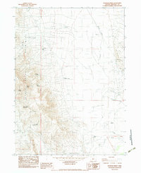
1982 Map of Boghole Spring
USGS Topo · Published 1983About this map
Mitchell Ranch and other isolated homesteads anchor this high-desert landscape in Malheur County during the early 1980s. The terrain is defined by the sharp elevations of the Oregon Canyon Mountains and the drainage of Oregon Canyon, where water sources like Boghole Spring, Juniper Spring, and Seep Spring provide critical points of interest in an otherwise arid expanse. The southern portion of the map is marked by the Old Military Reservation Boundary, reflecting historical land divisions that persisted into the late twentieth century.
Find a feature on this map
20 named features on this map. Tap any name to fly to it.
Don’t see what you’re looking for? This feature index may not catch every label — zoom into the map to look around manually.
Map Details
Editions of this 1982 Boghole Spring Map
This is the sole edition of this map. No revisions or reprints were ever made.
Other maps of this area

1882 · Paradise
USGS Topo · 1:250,000

1893 · Paradise
USGS Topo · 1:250,000

1955 · McDermitt
USGS Topo · 1:250,000

1955 · Jordan Valley
USGS Topo · 1:250,000

1957 · Jordan Valley
USGS Topo · 1:250,000

1958 · Jordan Valley
USGS Topo · 1:250,000

1959 · McDermitt
USGS Topo · 1:250,000

1959 · McDermitt
USGS Topo · 1:62,500

1959 · Jordan Meadow
USGS Topo · 1:62,500
1982 · Oregon Canyon Ranch
USGS Topo · 1:24,000