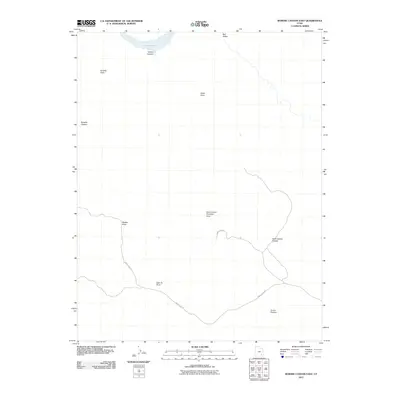
2011 Map of Bowdie Canyon East
USGS Topo · Published 2011About this map
Dark Canyon Primitive Area dominates the southern landscape of this 2011 survey, representing a significant protected wilderness corridor in San Juan County. The terrain transitions from the high elevations of Dark Canyon Plateau and the wide-open Horse Pasture toward the intricate drainage systems that feed into the Colorado River basin. In the northwest corner, a portion of Lake Powell is visible, carving into the sandstone via Palmer Canyon near the prominent Bowdie Point. Movement through this high desert environment is largely defined by the winding path of Sweet Alice Rd, which provides the primary access route across the plateau. This map documents a series of named overlooks and navigation markers essential for travel through the canyon country, including Middle Point, North Point, and Lean-To Point, alongside the deep cleft of Bowdie Canyon.
Find a feature on this map
12 named features on this map. Tap any name to fly to it.
Don’t see what you’re looking for? This feature index may not catch every label — zoom into the map to look around manually.
Map Details
Editions of this 2011 Bowdie Canyon East Map
This is the sole edition of this map. No revisions or reprints were ever made.
Other maps of this area

1885 · San Rafael
USGS Topo · 1:250,000
1885 · La Sal
USGS Topo · 1:250,000

1886 · Henry Mountains
USGS Topo · 1:250,000
1886 · Abajo
USGS Topo · 1:250,000
1892 · Abajo
USGS Topo · 1:250,000

1892 · Henry Mountains
USGS Topo · 1:250,000
1893 · Abajo
USGS Topo · 1:250,000
1935 · Elk Ridge
USGS Topo · 1:96,000
1940 · Elk Ridge
USGS Topo · 1:125,000
1952 · Mouth of Dark Canyon
USGS Topo · 1:62,500