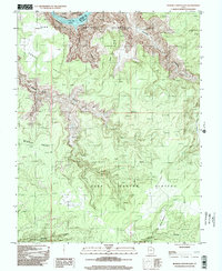
1996 Map of Bowdie Canyon East
USGS Topo · Published 2002About this map
The Colorado River winds through the northern reaches of this high-desert landscape, where the waters of Cataract Lake meet the steep topography of the Glen Canyon National Recreation Area. This mid-1990s survey highlights the dramatic elevation changes between the Dark Canyon Plateau and the deeply incised drainages of Gypsum Canyon and Bowdie Canyon. Human activity in this remote San Juan County terrain is sparse, centered primarily around a lone Landing Strip and named grazing areas like Horse Pasture. The map illustrates a complex network of canyons including Lean-To Canyon and Youngs Canyon, demonstrating the natural drainage patterns that define the region south of the Garfield and San Juan county line. Prominent landforms such as Bowdie Point and Middle Point serve as significant navigational landmarks across the plateau.
Find a feature on this map
17 named features on this map. Tap any name to fly to it.
Don’t see what you’re looking for? This feature index may not catch every label — zoom into the map to look around manually.
Map Details
Editions of this 1996 Bowdie Canyon East Map
This is the sole edition of this map. No revisions or reprints were ever made.
Other maps of this area

1885 · San Rafael
USGS Topo · 1:250,000

1885 · La Sal
USGS Topo · 1:250,000

1886 · Henry Mountains
USGS Topo · 1:250,000

1886 · Abajo
USGS Topo · 1:250,000

1892 · Abajo
USGS Topo · 1:250,000

1892 · Henry Mountains
USGS Topo · 1:250,000

1893 · Abajo
USGS Topo · 1:250,000

1935 · Elk Ridge
USGS Topo · 1:96,000

1940 · Elk Ridge
USGS Topo · 1:125,000

1952 · Mouth of Dark Canyon
USGS Topo · 1:62,500