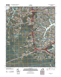
2011 Map of Bowers Hill
USGS Topo · Published 2011About this map
The Western Branch Elizabeth River and Bennett Creek define the branching geography of this Hampton Roads corridor, which was experiencing significant suburban infill by the early 21st century. The map documents a dense network of residential subdivisions such as Arbor Meadows, Holiday Point Estates, and Taylorwood Estates that replaced earlier agrarian plots. Notable infrastructure includes the Hodges Ferry Bridge and the critical transportation junction at Boone, where regional highways converge. Genealogists and local historians can locate several large memorial sites, including Triangle Cemetery, Meadowbrook Memorial Gardens, and Greenlawn Memorial Park. The presence of established marinas like Bennetts Creek Marina and established community hubs such as the Bowers Hill Post Office illustrates the blend of maritime heritage and modern transit-oriented development across the Chesapeake and Portsmouth borderlands.
Find a feature on this map
145 named features on this map. Tap any name to fly to it.
Don’t see what you’re looking for? This feature index may not catch every label — zoom into the map to look around manually.
Map Details
Editions of this 2011 Bowers Hill Map
This is the sole edition of this map. No revisions or reprints were ever made.
Other maps of this area

1907 · Norfolk
USGS Topo · 1:125,000

1919 · Smithfield
USGS Topo · 1:62,500

1919 · Suffolk
USGS Topo · 1:62,500

1921 · Newport News
USGS Topo · 1:62,500

1940 · Lake Drummond
USGS Topo · 1:62,500

1944 · Norfolk South
USGS Topo · 1:25,000

1945 · Lake Drummond
USGS Topo · 1:62,500

1948 · Norfolk South
USGS Topo · 1:24,000
1948 · Norfolk North
USGS Topo · 1:24,000

1949 · Chuckatuck
USGS Topo · 1:24,000