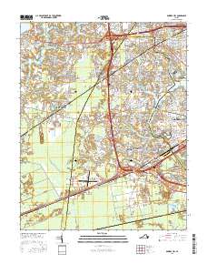
2016 Map of Bowers Hill
USGS Topo · Published 2016About this map
The Great Dismal Swamp looms over the southern reach of this 2016 survey, marking a stark transition from the dense residential developments of the City of Chesapeake and City of Suffolk. This modern landscape is defined by its complex highway interchanges near Boone and Bowers Hill, where major corridors like Portsmouth Blvd and Airline Blvd converge. These routes navigate around significant water features including the Western Branch Elizabeth River and Goose Cr.
Find a feature on this map
71 named features on this map. Tap any name to fly to it.
Don’t see what you’re looking for? This feature index may not catch every label — zoom into the map to look around manually.
Map Details
Editions of this 2016 Bowers Hill Map
This is the sole edition of this map. No revisions or reprints were ever made.
Other maps of this area

1907 · Norfolk
USGS Topo · 1:125,000

1919 · Smithfield
USGS Topo · 1:62,500

1919 · Suffolk
USGS Topo · 1:62,500

1921 · Newport News
USGS Topo · 1:62,500

1940 · Lake Drummond
USGS Topo · 1:62,500

1944 · Norfolk South
USGS Topo · 1:25,000

1945 · Lake Drummond
USGS Topo · 1:62,500

1948 · Norfolk South
USGS Topo · 1:24,000
1948 · Norfolk North
USGS Topo · 1:24,000

1949 · Chuckatuck
USGS Topo · 1:24,000