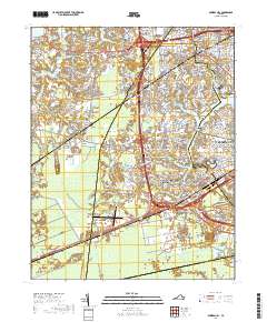
2019 Map of Bowers Hill
USGS Topo · Published 2019About this map
The Western Branch Elizabeth River and its network of tributaries, such as Bailey Cr and Goose Cr, define the eastern landscape of this Tidewater region. Modern suburban expansion is evident in the transition from established neighborhoods like Churchland and Pughsville to newer developments such as Ahoy Acres and Green Meadow Point. The map illustrates the convergence of critical transportation corridors at Bowers Hill, where major highways intersect near the Hampton Roads Executive Airport.
Find a feature on this map
314 named features on this map. Tap any name to fly to it.
Don’t see what you’re looking for? This feature index may not catch every label — zoom into the map to look around manually.
Map Details
Editions of this 2019 Bowers Hill Map
This is the sole edition of this map. No revisions or reprints were ever made.
Other maps of this area

1907 · Norfolk
USGS Topo · 1:125,000

1919 · Smithfield
USGS Topo · 1:62,500

1919 · Suffolk
USGS Topo · 1:62,500

1921 · Newport News
USGS Topo · 1:62,500

1940 · Lake Drummond
USGS Topo · 1:62,500

1944 · Norfolk South
USGS Topo · 1:25,000

1945 · Lake Drummond
USGS Topo · 1:62,500

1948 · Norfolk South
USGS Topo · 1:24,000
1948 · Norfolk North
USGS Topo · 1:24,000

1949 · Chuckatuck
USGS Topo · 1:24,000