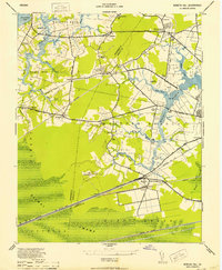
1952 Map of Bowers Hill
USGS Topo · Published 1952About this map
The Dismal Swamp and Cypress Swamp dominate the southern landscape of this mid-century survey, defining the geographical boundary between Nansemond and Norfolk counties. The map reveals a region defined by its waterborne and rail transit, where the Western Branch of the Elizabeth River system meets a dense network of competing rail lines including the Atlantic Coast Line, Southern, and Seaboard Air Line. Local life centered around small agricultural hubs and river crossings, evidenced by landmarks like Hodges Ferry and the Hodges Ferry Bridge. Scattered throughout the interior are several community anchors, including Bethlehem Church, the Popular Ch and Sch, and the settlement of Pughsville. The presence of the U.S. Naval Reservation and other military zones reflects the area's strategic importance during the 1940s and early 1950s.
Find a feature on this map
69 named features on this map. Tap any name to fly to it.
Don’t see what you’re looking for? This feature index may not catch every label — zoom into the map to look around manually.
Map Details
Editions of this 1952 Bowers Hill Map
This is the sole edition of this map. No revisions or reprints were ever made.
Other maps of this area

1907 · Norfolk
USGS Topo · 1:125,000

1919 · Smithfield
USGS Topo · 1:62,500

1919 · Suffolk
USGS Topo · 1:62,500

1921 · Newport News
USGS Topo · 1:62,500

1940 · Lake Drummond
USGS Topo · 1:62,500

1944 · Norfolk South
USGS Topo · 1:25,000

1945 · Lake Drummond
USGS Topo · 1:62,500

1948 · Norfolk South
USGS Topo · 1:24,000
1948 · Norfolk North
USGS Topo · 1:24,000

1949 · Chuckatuck
USGS Topo · 1:24,000