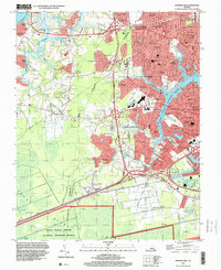
1994 Map of Bowers Hill
USGS Topo · Published 2000About this map
The Great Dismal Swamp encroaches upon the southern edge of this landscape, its dense interior preserved within the National Wildlife Refuge. To the north, the terrain transitions into a mosaic of suburban development and industrial infrastructure defined by the winding reaches of the Western Branch Elizabeth River. This area serves as a critical junction for regional transportation and defense, anchored by the US Naval Res (Craney Island Fuel Depot) and the Hampton Roads Airport.
Find a feature on this map
90 named features on this map. Tap any name to fly to it.
Don’t see what you’re looking for? This feature index may not catch every label — zoom into the map to look around manually.
Map Details
Editions of this 1994 Bowers Hill Map
This is the sole edition of this map. No revisions or reprints were ever made.
Other maps of this area

1907 · Norfolk
USGS Topo · 1:125,000

1919 · Smithfield
USGS Topo · 1:62,500

1919 · Suffolk
USGS Topo · 1:62,500

1921 · Newport News
USGS Topo · 1:62,500

1940 · Lake Drummond
USGS Topo · 1:62,500

1944 · Norfolk South
USGS Topo · 1:25,000

1945 · Lake Drummond
USGS Topo · 1:62,500

1948 · Norfolk South
USGS Topo · 1:24,000
1948 · Norfolk North
USGS Topo · 1:24,000

1949 · Chuckatuck
USGS Topo · 1:24,000