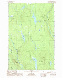
1986 Map of Bowlin Brook
USGS Topo · Published 1986About this map
Bowlin Camps stands as the primary outpost in this northern Maine wilderness during the mid-1980s, situated at the confluence of several waterway networks. The East Branch Penobscot River and the Seboeis River define the local topography, characterized by numerous river hazards such as The Hulling Machine Rapids, Spencer Rips, and the dramatic Grand Pitch Falls. This area, divided into the historical West of the East Line of the State (WELS) townships, shows a landscape dominated by remote lakes and ponds including Lunksoos Lake, Jerry Pond, and Bowlin Pond. The transition from river bottomlands at Gagnon Flat to the higher elevations of Peaked Mountain and Bear Mtn illustrates the varied relief of this logging and sporting region. The map provides a look at the intricate network of brooks and small ponds that feed into the larger river systems, essential for navigating the Penobscot watershed.
Find a feature on this map
35 named features on this map. Tap any name to fly to it.
Don’t see what you’re looking for? This feature index may not catch every label — zoom into the map to look around manually.
Map Details
Editions of this 1986 Bowlin Brook Map
This is the sole edition of this map. No revisions or reprints were ever made.
Other maps of this area

1927 · Katahdin
USGS Topo · 1:48,000

1930 · Katahdin
USGS Topo · 1:62,500

1949 · Katahdin
USGS Topo · 1:62,500

1953 · Stacyville
USGS Topo · 1:62,500

1954 · Shin Pond
USGS Topo · 1:62,500

1954 · Presque Isle
USGS Topo · 1:250,000

1954 · Millinocket
USGS Topo · 1:250,000

1955 · Traveler Mountain
USGS Topo · 1:62,500

1958 · Presque Isle
USGS Topo · 1:250,000

1958 · Millinocket
USGS Topo · 1:250,000