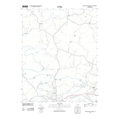
2010 Map of Bowling Green North
USGS Topo · Published 2010About this map
The Barren River winds through this landscape north of Bowling Green, defining the geography of Warren County through a series of pronounced meanders and island formations. These river bends created distinct landforms like Lock Bend and provided the foundation for numerous named river features, including Slim Island, Buckner Island, and McFarland Island. The settlement pattern follows the high ground above the river valley, with established communities such as Richardsville and Anna linked by a network of rural roads like Threlkel Ferry Rd and Pruitt Rd. Genealogists will find notable burial sites such as Taylor Cemetery near the Taylor Branch and Flora Cemetery in the northeast. From the industrial outskirts of Delafield to the heights of Billy Goat Hill, the map illustrates the ongoing relationship between the river's path and the development of north-central Kentucky.
Find a feature on this map
64 named features on this map. Tap any name to fly to it.
Don’t see what you’re looking for? This feature index may not catch every label — zoom into the map to look around manually.
Map Details
Editions of this 2010 Bowling Green North Map
This is the sole edition of this map. No revisions or reprints were ever made.
Other maps of this area

1914 · Little Muddy
USGS Topo · 1:62,500

1921 · Bowling Green
USGS Topo · 1:62,500

1922 · Brownsville
USGS Topo · 1:62,500

1923 · Bowling Green
USGS Topo · 1:62,500

1923 · Brownsville
USGS Topo · 1:62,500

1952 · Rockfield
USGS Topo · 1:24,000

1954 · Evansville
USGS Topo · 1:250,000

1954 · Bowling Green North
USGS Topo · 1:24,000

1954 · Bristow
USGS Topo · 1:24,000
1954 · Brownsville
USGS Topo · 1:24,000