
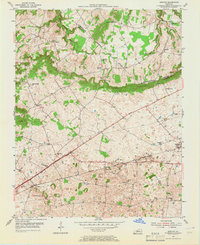
1954 Map of Bristow
USGS Topo · Published 1955About this map
The Knobs dominate the central landscape of this Warren and Edmonson County borderland, creating a distinct topographical break between the northern drainage of Little Beaver Dam Creek and the southern plains. In the mid-1950s, the corridor is defined by the heavy infrastructure of the Louisville and Nashville railroad and the Blue Star Memorial Highway, which stitch together agricultural settlements like Oakland and Bristow. The map reveals a dense network of local landmarks essential for genealogists, including Penns Chapel, Otter Gap Ch, and several family burial sites such as Tate Cem and Cook Cem. The presence of the Louisville and Nashville Pipe Line alongside traditional schools like Chalybeate Sch and Bristow Sch illustrates an era where rural tradition met burgeoning industrial utility.
Find a feature on this map
36 named features on this map. Tap any name to fly to it.
Don’t see what you’re looking for? This feature index may not catch every label — zoom into the map to look around manually.
Map Details
Editions of this 1954 Bristow Map
2 editions found
Other maps of this area

1921 · Bowling Green
USGS Topo · 1:62,500

1922 · Brownsville
USGS Topo · 1:62,500

1922 · Mammoth Cave
USGS Topo · 1:62,500

1923 · Bowling Green
USGS Topo · 1:62,500

1923 · Mammoth Cave
USGS Topo · 1:62,500

1923 · Brownsville
USGS Topo · 1:62,500

1926 · Scottsville
USGS Topo · 1:62,500

1954 · Evansville
USGS Topo · 1:250,000

1954 · Bowling Green North
USGS Topo · 1:24,000
1954 · Brownsville
USGS Topo · 1:24,000