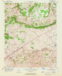
1954 Map of Bristow
USGS Topo · Published 1965About this map
The Knobs rise distinctly across the center of this landscape, marking a significant topographical transition between the Warren and Edmonson County lines. This mid-century survey captures a network of rural communities interconnected by the Louisville and Nashville railroad and the Dixie Line, alongside the Blue Star Memorial Highway. The region is densely populated with community landmarks, from the Oakland Sch and Chalybeate Sch to a high concentration of country churches including Penns Chapel, Cowles Chapel, and Jackson Grove Ch.
Find a feature on this map
37 named features on this map. Tap any name to fly to it.
Don’t see what you’re looking for? This feature index may not catch every label — zoom into the map to look around manually.
Map Details
Editions of this 1954 Bristow Map
2 editions found
Other maps of this area

1921 · Bowling Green
USGS Topo · 1:62,500

1922 · Brownsville
USGS Topo · 1:62,500

1922 · Mammoth Cave
USGS Topo · 1:62,500

1923 · Bowling Green
USGS Topo · 1:62,500

1923 · Mammoth Cave
USGS Topo · 1:62,500

1923 · Brownsville
USGS Topo · 1:62,500

1926 · Scottsville
USGS Topo · 1:62,500

1954 · Evansville
USGS Topo · 1:250,000

1954 · Bowling Green North
USGS Topo · 1:24,000

1954 · Bristow
USGS Topo · 1:24,000