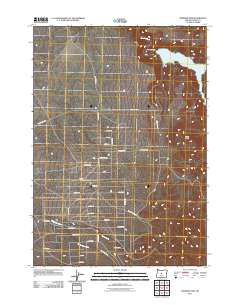
2011 Map of Bowman Dam
USGS Topo · Published 2011About this map
Bowman Dam anchors the landscape where the Crooked River enters the expansive waters of the Prineville Reservoir. Located in Crook County during the early 21st century, this area demonstrates a hybrid of hydraulic engineering and suburban development. A dense network of residential lanes—many named for trees like Redwood Ln, Sequoia Ln, and Se Walnut Ln—stretches across the terrain west of the reservoir, indicating significant rural subdivision. The landscape is punctuated by prominent geological features such as Taylor Butte and Bear Creek Butte, while a complex system of seasonal and perennial drainages including Perry Creek and Williamson Creek flow toward the river valley. The infrastructure is dominated by the arterial Reservoir Rd and Bear Creek Rd, providing access to the recreational and residential tracts that characterize this high-desert region.
Find a feature on this map
38 named features on this map. Tap any name to fly to it.
Don’t see what you’re looking for? This feature index may not catch every label — zoom into the map to look around manually.
Map Details
Editions of this 2011 Bowman Dam Map
This is the sole edition of this map. No revisions or reprints were ever made.
Other maps of this area
1946 · Eagle Rock
USGS Topo · 1:62,500
1948 · Eagle Rock
USGS Topo · 1:62,500

1955 · Crescent
USGS Topo · 1:250,000

1955 · Bend
USGS Topo · 1:250,000

1957 · Crescent
USGS Topo · 1:250,000

1957 · Bend
USGS Topo · 1:250,000

1958 · Crescent
USGS Topo · 1:250,000
1958 · Bend
USGS Topo · 1:250,000
1962 · Powell Buttes
USGS Topo · 1:62,500
1967 · Brothers NW
USGS Topo · 1:24,000