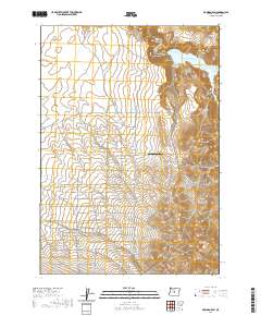
2020 Map of Bowman Dam
USGS Topo · Published 2020About this map
Bowman Dam anchors the northern landscape of this Central Oregon quadrangle, holding back the Crooked River to form the sprawling Prineville Reservoir. The eastern edge of the water is defined by Powder House Cove, while the surrounding terrain is marked by prominent high points such as Taylor Butte and Bear Creek Butte. A distinct grid of residential or agricultural lanes north of Bear Creek Butte is named for a variety of trees, including Myrtlewood Ln, Sequoia Ln, and Almond Ln. This systematic naming pattern suggests a planned development or orchard-style division of the high desert land. To the west, Agape Farm Airport provides a small aviation waypoint amidst a network of rural routes like S Reservoir Rd and Cascade Way, while drainage flows through Perry Cr and Williamson Cr toward the south.
Find a feature on this map
49 named features on this map. Tap any name to fly to it.
Don’t see what you’re looking for? This feature index may not catch every label — zoom into the map to look around manually.
Map Details
Editions of this 2020 Bowman Dam Map
This is the sole edition of this map. No revisions or reprints were ever made.
Other maps of this area

1946 · Eagle Rock
USGS Topo · 1:62,500

1948 · Eagle Rock
USGS Topo · 1:62,500

1955 · Crescent
USGS Topo · 1:250,000

1955 · Bend
USGS Topo · 1:250,000

1957 · Crescent
USGS Topo · 1:250,000

1957 · Bend
USGS Topo · 1:250,000

1958 · Crescent
USGS Topo · 1:250,000

1958 · Bend
USGS Topo · 1:250,000

1962 · Powell Buttes
USGS Topo · 1:62,500

1967 · Brothers NW
USGS Topo · 1:24,000