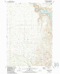
1988 Map of Bowman Dam
USGS Topo · Published 1988About this map
Bowman Dam stands as the central engineering feature of this central Oregon landscape, impounding the Crooked River to create the expansive Prineville Reservoir. This 1988 map reflects a region managed for both water resources and conservation, highlighted by the Prineville Reservoir State Wildlife Area along the northern banks. The terrain transitions from the water's edge to significant volcanic elevations, including Taylor Butte and Bear Creek Butte in the southeast. A network of resource extraction is evident through numerous prospects and a quarry located near the dam. Water sources are critical in this arid environment, with several unnamed springs and springs documented alongside drainage systems like Williamson Creek and Bear Creek. Bear Creek Road provides the primary east-west transit across the high desert plateaus and through Rocky Canyon.
Find a feature on this map
17 named features on this map. Tap any name to fly to it.
Don’t see what you’re looking for? This feature index may not catch every label — zoom into the map to look around manually.
Map Details
Editions of this 1988 Bowman Dam Map
This is the sole edition of this map. No revisions or reprints were ever made.
Other maps of this area

1946 · Eagle Rock
USGS Topo · 1:62,500

1948 · Eagle Rock
USGS Topo · 1:62,500

1955 · Crescent
USGS Topo · 1:250,000

1955 · Bend
USGS Topo · 1:250,000

1957 · Crescent
USGS Topo · 1:250,000

1957 · Bend
USGS Topo · 1:250,000

1958 · Crescent
USGS Topo · 1:250,000

1958 · Bend
USGS Topo · 1:250,000

1962 · Powell Buttes
USGS Topo · 1:62,500

1967 · Brothers NW
USGS Topo · 1:24,000