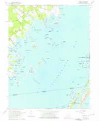
1964 Map of Boxiron
USGS Topo · Published 1976About this map
The small settlement of Boxiron sits at the edge of a complex coastal landscape where the mainland meets the vast waters of Chincoteague Bay. This mid-century survey reveals an economy and way of life deeply tied to the shore, marked by a series of landings such as Figgs Landing, Truitt Landing, and Hudson Landing. These points of access served as vital conduits for the local residents, connecting agricultural land via routes like Boxiron Road and Taylor Landing Road to the productive waters of Brockatonorton Bay and Johnson Bay.
Find a feature on this map
91 named features on this map. Tap any name to fly to it.
Don’t see what you’re looking for? This feature index may not catch every label — zoom into the map to look around manually.
Map Details
Editions of this 1964 Boxiron Map
3 editions found
Other maps of this area

1901 · Snow Hill
USGS Topo · 1:62,500

1901 · Green Run
USGS Topo · 1:62,500

1938 · Green Run
USGS Topo · 1:62,500

1942 · Chincoteague East
USGS Topo · 1:24,000

1942 · Snow Hill
USGS Topo · 1:24,000

1942 · Tingles Island
USGS Topo · 1:24,000

1942 · Wesley
USGS Topo · 1:24,000

1943 · Snow Hill
USGS Topo · 1:31,680

1943 · Boxiron
USGS Topo · 1:31,680

1943 · Whittington Point
USGS Topo · 1:31,680