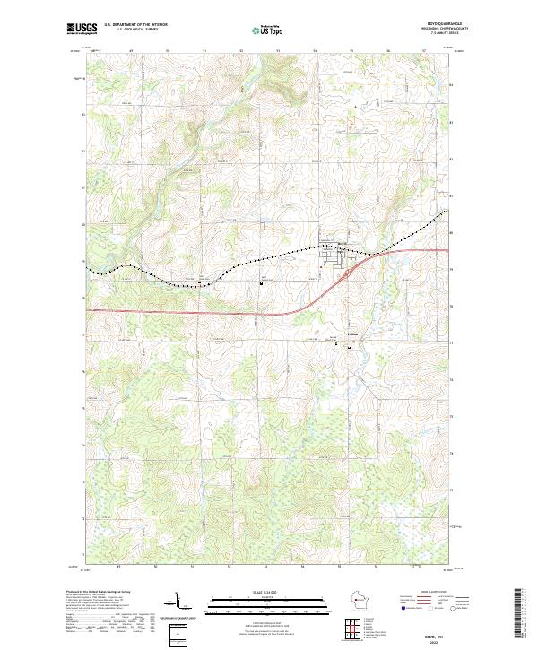
2022 Map of Boyd
USGS Topo · Published 2022About this map
The Yellow River cuts a winding path through this western Wisconsin landscape, framing the village of Boyd as it appeared in the early 21st century. The map reveals a strictly gridded rural township structure defined by the intersection of numerous county highways and avenues, including Co Hwy X and Co Hwy D. This area maintains its agricultural character, evidenced by the small settlement of Edson and a series of rural cemeteries that mark the spiritual and genealogical history of the community. Several tributary streams such as Paint Cr and Lotz Cr drain the surrounding fields, feeding into the river system. Researchers can identify local landmarks like the Po in Boyd and trace the established property boundaries of the t29n r6w and t28n r5w townships.
Find a feature on this map
50 named features on this map. Tap any name to fly to it.
Don’t see what you’re looking for? This feature index may not catch every label — zoom into the map to look around manually.
Map Details
Editions of this 2022 Boyd Map
This is the sole edition of this map. No revisions or reprints were ever made.
Other maps of this area

1951 · Cornell
USGS Topo · 1:62,500

1951 · Gilman
USGS Topo · 1:62,500

1952 · Cadott
USGS Topo · 1:62,500

1952 · Stanley
USGS Topo · 1:62,500

1953 · Eau Claire
USGS Topo · 1:250,000

1953 · Rice Lake
USGS Topo · 1:250,000

1958 · Eau Claire
USGS Topo · 1:250,000

1959 · Rice Lake
USGS Topo · 1:250,000

1964 · Eau Claire
USGS Topo · 1:250,000
1973 · Colburn
USGS Topo · 1:24,000