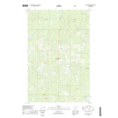
2020 Map of Boyer Mountain
USGS Topo · Published 2020About this map
Kaniksu National Forest dominates this mountain landscape along the border of Stevens and Pend Oreille counties. High elevations are marked by significant peaks, including Boyer Mtn, Power Peak, and Granite Mtn. The hydrology of the area is defined by the headwaters and drainages of the Middle Fork Calispell Cr and S Fork Calispell Cr, which carve through the high terrain. The southern portion of the quadrangle shows the transition toward more accessible land with the appearance of Slate Rd and Granite Loop. This survey documents a largely undeveloped wilderness characterized by steep topographic relief, where features like Little Blue Grouse Mtn and Brush Mtn remain primary landmarks. Smaller tributaries like Spring-Heel Cr and Heel Cr drain the southern slopes near the county line, providing a detailed look at the drainage patterns of the Selkirk Mountains.
Find a feature on this map
23 named features on this map. Tap any name to fly to it.
Don’t see what you’re looking for? This feature index may not catch every label — zoom into the map to look around manually.
Map Details
Editions of this 2020 Boyer Mountain Map
This is the sole edition of this map. No revisions or reprints were ever made.
Other maps of this area

1927 · Chewelah
USGS Topo · 1:125,000

1930 · Chewelah
USGS Topo · 1:125,000

1936 · Newport
USGS Topo · 1:96,000

1942 · Newport
USGS Topo · 1:125,000

1958 · Sandpoint
USGS Topo · 1:250,000

1963 · Sandpoint
USGS Topo · 1:250,000

1964 · Goddards Peak
USGS Topo · 1:24,000

1964 · Chewelah Mtn
USGS Topo · 1:62,500
1965 · Nelson Peak
USGS Topo · 1:24,000
1965 · Deer Lake
USGS Topo · 1:24,000