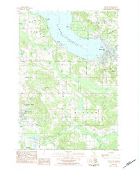
1983 Map of Boyne City
USGS Topo · Published 1984About this map
Lake Charlevoix dominates the landscape of this Charlevoix County study, where the waters of the South Arm meet the main basin. The town of Boyne City serves as a central hub, showing its established street grid, municipal buildings like the Library, and recreational spaces including Veterans Mem Park. The terrain rises sharply to the east at Avalanche Mountain, while the surrounding rural townships of Evangeline, Eveline, and Wilson are defined by a network of family-named roads and remote water bodies like Dyer Lake and Patricia Lake.
Find a feature on this map
71 named features on this map. Tap any name to fly to it.
Don’t see what you’re looking for? This feature index may not catch every label — zoom into the map to look around manually.
Map Details
Editions of this 1983 Boyne City Map
This is the sole edition of this map. No revisions or reprints were ever made.
Other maps of this area

1955 · Cheboygan
USGS Topo · 1:250,000

1958 · Cheboygan
USGS Topo · 1:250,000

1958 · Bayshore
USGS Topo · 1:62,500

1958 · Petoskey
USGS Topo · 1:62,500

1961 · Boyne Falls
USGS Topo · 1:62,500

1961 · Boyne City
USGS Topo · 1:62,500

1975 · Boyne City NW
USGS Topo · 1:24,000

1975 · Petoskey SW
USGS Topo · 1:24,000

1975 · Boyne City NE
USGS Topo · 1:24,000

1982 · Petoskey
USGS Topo · 1:100,000