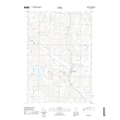
2019 Map of Boyne Falls
USGS Topo · Published 2019About this map
Boyne Falls serves as a central hub in this landscape where the N Br Boyne River and S Br Boyne River converge. The area is characterized by significant topographic relief, most notably at Boyne Mtn, which dominates the central portion of the map. Transport and infrastructure are well-defined by the Great Lakes Central Railroad corridor running north-south through the valley, complemented by two aviation facilities: the Boyne City Municipal Airport and the private Boyne Mountain Airport.
Find a feature on this map
84 named features on this map. Tap any name to fly to it.
Don’t see what you’re looking for? This feature index may not catch every label — zoom into the map to look around manually.
Map Details
Editions of this 2019 Boyne Falls Map
This is the sole edition of this map. No revisions or reprints were ever made.
Other maps of this area

1955 · Cheboygan
USGS Topo · 1:250,000

1958 · Cheboygan
USGS Topo · 1:250,000

1958 · Bayshore
USGS Topo · 1:62,500

1958 · Petoskey
USGS Topo · 1:62,500

1961 · Boyne Falls
USGS Topo · 1:62,500

1961 · Boyne City
USGS Topo · 1:62,500

1975 · Petoskey SW
USGS Topo · 1:24,000

1975 · Boyne City NE
USGS Topo · 1:24,000

1982 · Petoskey
USGS Topo · 1:100,000
1983 · Bay Shore
USGS Topo · 1:25,000